Pilot Danny Gill recounts an eventful day of flight training with Christiaan Haak in Kenya.
I've been training for 6 months in Kenya, going through the process of license conversion and renewing my IFR (Instrument rating) on a C208 Caravan. I am nearing the end of my orientation flight training. I'd had two flights earlier in the week and am planning my “check ride” (so I can progress to solo flying).
This Friday I was flying the shuttle service to Marsabit. It was an interesting day with lots of different aspects to it. We left the town of Wilson in showery, cloudy conditions. It was a true “instrument departure”, going into cloud that started about 500 feet above ground. I was under training so my instructor, Christiaan, told me that for this departure I wasn't allowed to use the autopilot and I had to fly it all by hand.
We were in cloud right up to 10,000'. Once on top of the cloud I was busy setting up radios and navigation checks. The route we take goes quite close to Mt Kenya. In fact, since as we're actually lower than it at 13,000' I had to maintain visual contact with it to ensure we had the appropriate clearance.
Our first stop was Log Logo. While there I got the bags out for passengers and got the paperwork ready for the next flight, then had time to chat to the three ladies we'd brought from Nairobi. Two were German volunteers who were going out to rural Ileret for 3 weeks to train teachers. They came out several times a year for this. One of the ladies had grown up in Kenya and loved getting back to her childhood home while for the other it was an exciting opportunity to see part of her friend’s child hood.
We then left Log logo for the 10-minute trip to Marsabit. I stayed at 5,500 feet and had great views of the rainforests and craters around the hill on which Marsabit sits.
We had a quick turn around and picked up some more regulars from Marsabit. Our next stop was Korr, which had a category C strip. This means a pilot needs a certain amount of experience and training to land there, so Christiaan took over and flew the 18 minute leg. We did a low pass on arrival, noting the hill near the start, the dogleg in the runway, it’s rough surface and goats to the side! Then we came around and made our approach and landing, stopping at the end of the runway where our passengers were already waiting.
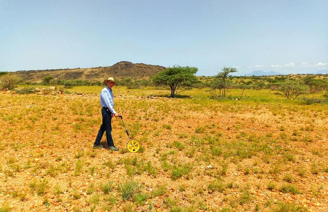
As we hadn't been to this runway in a Caravan for some time, Christiaan and I walked the length of the strip to measure it and note features that we could put onto a runway diagram to help future pilots in their landing and takeoff planning. We measured it to be 760 meters and thankfully somebody drove to the end to take us back to the plane in the 35C temps!
I was allowed to take off from Korr, so before taking off we discussed our plan and ensured that we knew our critical points. Training includes aiming to land accurately on specific points, being able to take off on short strips and generally operating to a high level of competency and accuracy—so it was great to put all those things to use in making a safe take off on a challenging runway.
On the way home, we faced the three regular biggest challenges of flying in places like Kenya: weather, terrain and traffic.
After reaching cruising altitude of 12,000' out of Korr I noticed an aircraft on our TAS (Traffic Advisory System). It was several thousand feet above me, so I wasn't too worried about it. However not long after it start to descend quickly. I tried calling the aircraft on three different radio channels to let him know our proximity was within 5 miles, reducing down to about 3 miles, but could not get in contact with him. The plane proceeded to descend about 5000 feet below me before shooting up through my level again very quickly! If it wasn't for the TAS I wouldn't have even known he was there since, even though I tried my best, I never visually spotted him. Our aircraft also has weather radar and TAWS (terrain awareness and warning system). These three tools are invaluable in navigating safely through the challenges we face. Before we take off we look at our maps to learn about the terrain and check weather. These systems provide great awareness for safe flying!
Coming into Nairobi there is still some terrain which requires careful planning and tracking to maintain safe distances at all times. Early in the week we had had the sobering reminder of how dangerous terrain and bad weather can be, when another company lost an aircraft in a fatal accident in the very terrain I was flying.
The controller was “vectoring” aircraft onto the main approach for the international airport Jomo Kenyata and I got slotted in behind another MAF aircraft returning from Lokichoggio.
At the end of each day we usually debrief with the instructors and gain tips, advice and wisdom from what they've observed. I was encouraged by having performed better on this day and was grateful for the encouraging feedback from my instructor. Training can be gruelling, and I find it's always playing on my mind, that I never truly stop thinking about the standards and requirements to be met. But at we'd seen from that week’s events, there is a reason we aim high and when we walk away at the end of the day we can be confident in our credibility.